Maps of the Concentration Camps and Killing Centers in Nazi-Occupied Europe
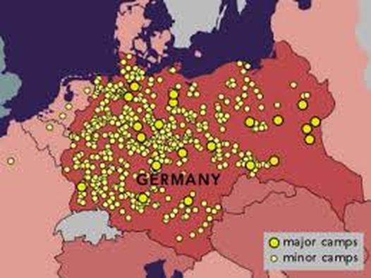
The following visual displays were selected in order to show the students just how many concentration camps and killing centers the Nazi Party operated at their peak during World War II. While the major camps such as Auschwitz, Bukenvald, and Bergen-Belsin are relatively well known and recognized, minor camps such as Treblinka and Sobibor were often known as killing centers. Unlike the prisoners remained at the concentration camps for years to work, killing centers were just that: prisoners were dead on average within 2 hours of arrival.
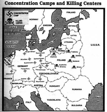
The first map shows just how numerous the concentration camps were in the German empire and across Western Europe. The second map shows the larger of the concentration camps and killing centers, with the majority of the killing centers localized in Poland - an area where Jews were more heavily hunted and persecuted.
The first map shows just how numerous the concentration camps were in the German empire and across Western Europe. The second map shows the larger of the concentration camps and killing centers, with the majority of the killing centers localized in Poland - an area where Jews were more heavily hunted and persecuted.
These resources were selected with the following learning goals in mind:
Common Core State Standards
- I will view maps showing the locations of the concentration camps and killing centers in Germany's growing empire.
- I will analyze the maps, looking for any patterns or trends, and making general observations.
Common Core State Standards
- CCSS.ELA-Literacy.SL.8.2 Analyze the purpose of information presented in diverse media and formats (e.g., visually, quantitatively, orally) and evaluate the motives (e.g., social, commercial, political) behind its presentation.
- CCSS.ELA-Literacy.RI.8.7 Evaluate the advantages and disadvantages of using different mediums (e.g., print or digital text, video, multimedia) to present a particular topic or idea.
